Geographic Information Systems
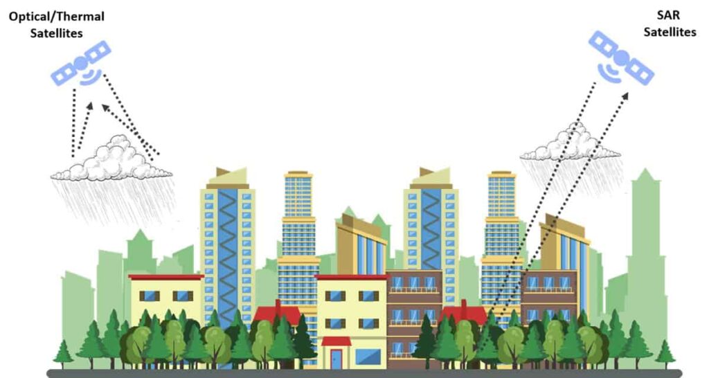
Geographic Information Systems enable water utilities to manage systems and monitor flows. We use SAR satellite images in bands L or C to penetrate even heavy cloud cover and normal vegetation. We can identify water’s reflectance values in any weather, day or night, ensuring that water companies always have the data they need to find leaks and maintain their systems.

Our Analytical Approach
1. Acquire Satellite Data

We acquire satellite data of the geographical area under analysis, then combine that data with additional geographical, weather, and water pipeline information.
2. Organize Information

All data is passed through adapters for transformation into a usable format. We combine the data with historical information for Deep Learning and accurate processing.
3. Process Integrated Data

Our hydraulic AI algorithm processes the integrated data to identify the spectral signatures indicative of water leaks. Radiometric corrections ensure an accurate final analysis.
4. Improve Monitoring

Using the latest weather information and geographical data, we verify the locations of any incidents to check any apparent leaks and eliminate false positives.
5. Report & Implement Results

We report the results of our analysis through web and mobile applications. We can also integrate with customer APIs and make our raw files available for review.
Overall Monitoring Process
1. Locate

We apply AI algorithms to SAR satellite and geographic data, weather reports, and water pipeline information to identify the location of the leak or flood.
2. Report

Once an incident is confirmed, we report its location using our web portal or mobile app, or through an API integrated with a customer’s existing application.
3. Assign

Customers assign a field engineer to act on the incident. The engineer reviews the information provided and determines an appropriate course of action.
4. Verify

The customer verifies the incident themselves. A field engineer visits the site, sees the problem, and measures the scale of the incident so that further action can be determined.
5. Repair

The customer implements a repair, updates the incident’s status and notifies users and local authorities. They may also perform a cause analysis and take preventive steps.
6. Analyze

We give customers a real time dashboard to track incidents and historical trends to identify recurring problems. Customers always have key performance indicators.
Complex Scenarios
Environmental conditions can affect the ability of any GIS water monitoring system to detect leaks. When requesting an analysis, it is important to understand the conditions in which the event has taken place.
| Event Condition | Is leak detectable? | Possibility of false alarm | Remark |
|---|---|---|---|
| Normal weather | Major leak: Yes Minor leak: Yes |
No | Monitoring water ponding can identify major leaks in normal weather. Monitoring changes in moisture of barren soil can identify minor leaks. |
| Light rain (no ponding or inundation) | Major leaks: Yes Minor leaks: No |
No | Significant leaks leading to ponding can be identified. Minor leaks that only cause a change in soil moisture cannot be identified during light rain. |
| Heavy rain (with ponding/inundation) | Major leaks: No Minor leaks: No |
No | Since heavy rain will cause widespread ponding, there will be no false alarms. However, water monitoring cannot detect leaks during periods of heavy rain. |
| Snow | Minor leaks: No Major leaks: Yes |
No | Snow melts cause conditions similar to light rain. Water monitoring can identify major leaks but not minor leaks. |
| Leaks from other sources
(e.g. leak from a water tanker near a pipeline) |
Major leaks: Yes Minor leaks: Yes |
Yes | Leaks from any sources will be identified. However, they will require additional information to minimize false positives. |

Key Benefits of GIS Water Monitoring
Want to Xplore more?
Find out how we can help your organization navigate its next challenge. Let us know how you want to grow so that we can serve you better.

